From scorching Europe to freezing ‘Snobart’ – what’s with the crazy weather?
Southeast Australia is in for more icy temperatures this week, as a high-pressure system strengthens and Tasmania is hit with snow in low-lying areas – but the extreme weather is having the opposite effect on the opposite site of the globe.
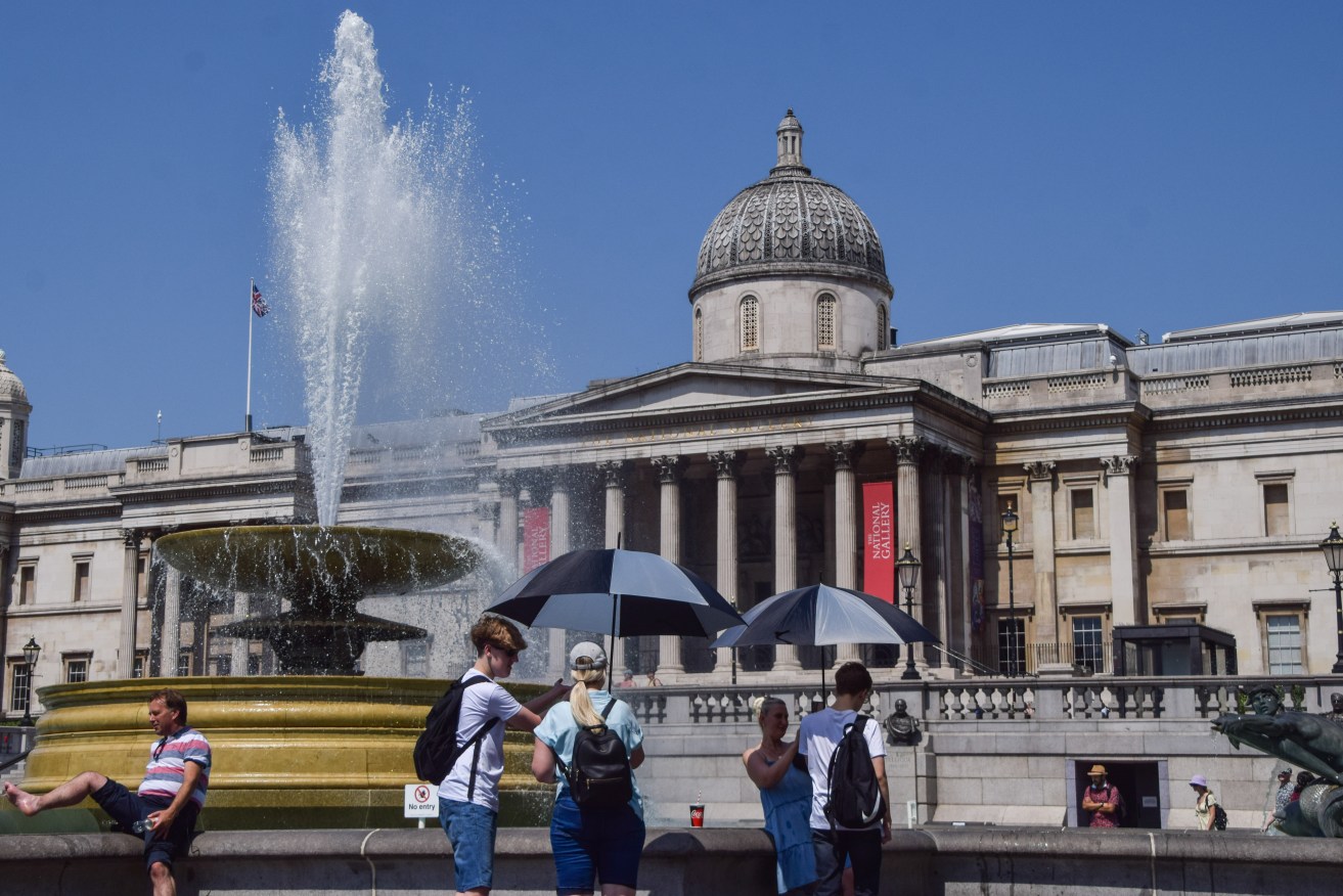
People shield themselves from the sun with umbrellas in Trafalgar Square as the UK records its highest ever temperatures. The Met Office has issued its first-ever red warning over extreme heat in the UK. (Photo by Vuk Valcic / SOPA Images/Sipa USA)
A strong cold front over the weekend pushed snow levels down to about 300m around Hobart as snow settled as low as about 150m above sea level for brief periods, with flurries also at sea level in southern parts of Tasmania.
Hobart recorded its coldest day since August 2016 on Monday, with a maximum of 7.3C, the Bureau of Meteorology said. Kunanyi/Mount Wellington reached minus 3.9C, the coldest maximum it has had since August 2005.
But while Australia’s south-east shivered, the United Kingdom recorded its highest ever temperature of 40C as a heatwave gripping Europe intensifies, forcing train tracks to buckle and fuelling a spate of fires across London.
Firefighters in southwestern France have battled to contain massive forest wildfires and Britain has recorded its highest-ever temperature, buckling train tracks and igniting grassfires in dry conditions around London.
Southern and western Germany and Belgium were also braced for potentially record-breaking temperatures on Tuesday as the heatwave, which scientists attribute to climate change, edged north and east.
A wildfire fuelled by strong winds raged on a mountainous area near homes on the outskirts of the Greek capital, prompting authorities to order the evacuation of four areas.
Fires were also reported in woods near Rome, as well as on the shores of Lake Orta north of Milan and near the northeastern city of Trieste, forcing the authorities to close a motorway and railway line, with temperatures set to stay high.
A temperature of more than 40C was provisionally recorded for the first time in Britain, the Met Office said.
Authorities have put Britain on a state of “national emergency” over the unprecedented temperatures. Train routes were cancelled and electricity companies reported mass outages. Network Rail tweeted pictures showing bends and kinks in the tracks.
To the east of the capital a large fire engulfed homes in the village of Wennington. Elsewhere large grass areas around the capital were on fire.
In southwestern France, the wine-growing Gironde region saw its biggest wildfires in more than 30 years and authorities said a man had been detained on suspicion of arson.
The fires have spread across 19,300 hectares in the countryside surrounding Bordeaux since July 12, forcing 34,000 people to leave their homes.
About 2000 firefighters, supported by eight water-bomber aircraft, were battling the blazes.
With human-caused climate change triggering droughts, the number of extreme wildfires is expected to increase 30 per cent within the next 28 years, according to a February 2022 UN report.
“We are seeing more frequent heatwaves, and the heatwaves are hotter than they would have been without climate change,” Friederike Otto, senior lecturer in climate science at Imperial College London, told Reuters.
The health impact of the heatwave has been in focus, with particular care given to the elderly and vulnerable.
Hot night-time temperatures were also hindering firefighting responses across Europe and worsening health conditions as the night hours failed to provide a cooling reprieve, experts said on Tuesday.
In Italy, temperatures were expected to hit 40C across a swathe of the north and centre throughout the week, as well as in the southern heel of Italy’s boot, Puglia, and the islands of Sardinia and Sicily.
Five cities were placed on the highest red alert because of the heatwave on Tuesday. The alert will cover nine cities on Wednesday, rising to 14 on Thursday, including many of Italy’s largest metropolitan areas, including Rome, Milan and Florence.
Although the mercury dipped back towards more normal summer levels in Spain and Portugal, firefighters in both countries were still battling multiple blazes.
The Met Office said a new provisional record temperature of 40.3C was recorded in Coningsby, in central England, with 29 sites across the country experiencing temperatures in excess of the previous high of 38.7C recorded in 2019.
Stephen Belcher at the Met Office said he had not expected to see such temperatures in the UK in his career.
“Research conducted here at the Met Office has demonstrated that it’s virtually impossible for the UK to experience 40C in an undisrupted climate but climate change driven by greenhouse gases has made these extreme temperatures possible,” he said.
Train services on major routes from London up the east and west coast of the country were cancelled, electricity companies reported mass outages and normally busy city centres appeared quiet.
Network Rail tweeted a number of pictures showing large bends and kinks in rail tracks.
London Fire Brigade declared a major incident and urged people to stop having barbecues as hundreds of firefighters battled blazes across the capital.
To the east, a large fire engulfed homes in the village of Wennington, with flames tearing across about 40 hectares of neighbouring tinder-dry fields.
Elsewhere large grassland areas around the capital caught fire, billowing smoke over major roads and nearby areas.
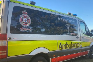
London’s Ambulance Service said it had been dealing with 400 calls an hour because of the extreme heat.
“We are seeing an increase in the number of patients experiencing heat exposure, breathing difficulties, dizziness and fainting,” said Peter Rhodes, the deputy director of ambulance operations.
The UK, which can struggle to maintain key transport services in extreme heat or snow, had been put on a state of national emergency over the unprecedented temperatures.
“My thanks go to all the firefighters and frontline services who are working incredibly hard to keep us safe on this scorching day,” Prime Minister Boris Johnson said on Twitter.
Transport minister Grant Shapps said there had been a considerable amount of travel disruption.
“Infrastructure, much of which was built from the Victorian times, just wasn’t built to withstand this type of temperature,” he said.
Operator Network Rail advised passengers to only travel if absolutely necessary.
“Extreme Heat: All services stopped. Do not come to the station,” Avanti West Coast, which runs services from London to cities such as Liverpool, Manchester and Glasgow, said on Twitter.
City of Hobart bushland manager John Fisher said it felt like minus 20C on the mountain on Monday when cutting winds were factored in.
“It’s so close … the mountain looks fantastic, it’s got white snow on it (and people say), ‘Let’s go up and have a look’,” he told AAP.
“When they get up there, it’s a completely different world.”
Fisher and his team conduct daily inspections to assess conditions on the mountain, but were hampered on Monday mainly by a thick layer of ice on the road.
They reopened the mountain to the Springs on Tuesday morning, and were monitoring ice on the roads to determine how far it should be opened on Wednesday.
No fresh snow was forecast for the rest of the week, but what was already there would take days to melt away, the bureau said.
Snow would probably remain at levels above about 1200m until at least Friday.
A bureau road alert to drivers to be wary of icy roads remained in place on Tuesday for the North-West Coast, Central North, North-East, western, Central Plateau, Midlands, East Coast, upper Derwent Valley and South-East forecast districts.
“The real focus now is road conditions,” bureau meteorologist Luke Johnston said.
“There’s a lot of elevated roads in Tassie that have either had or still have snow on them, so limiting transport around the state.”
He said there was always plenty of black ice about.
Snow levels were expected to hover down to about 800m into early Tuesday more broadly across Australia’s southeast.
Minimum temperatures across large parts of Tasmania and Victoria, as well as areas of NSW and eastern South Australia, were forecast to drop between 4C and 8C below average from Tuesday.
Meteorologists were expecting widespread frost, with severe frost possible across some inland areas.
Hobart was forecast to have the chance of morning frosts until Friday, with Launceston expected to see frosts through to Thursday.
The bureau said temperatures were likely to drop below minus 2C in some inland areas.
“These very cold nights may even extend towards central Australia by Wednesday and Thursday morning as well,” senior forecaster Miriam Bradbury said.