Storms latest: Southeast Queensland braces for ‘life-threatening’ flash floods
Severe thunderstorms are continuing to develop along southeast Queensland, bringing damaging winds, large hail, heavy rain and the possibility of “life-threatening” flash flooding, according to weather bureau warnings.
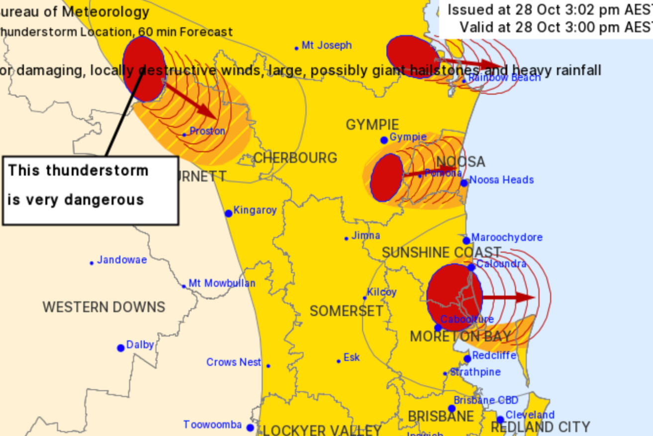
(Photo: Supplied, Bureau of Meteorology)
Queensland’s Bureau of Meteorology (BOM) has issued a severe thunderstorm warning for the region, predicting flash flooding for some areas.
The bureau said very dangerous thunderstorms were detected near Kilcoy, northern Lake Wivenhoe, Somerset Dam, Lake Somerset and Mount Kilcoy.
Very dangerous thunderstorms were also forecast for Caboolture, and areas around Caloundra, Peachester, Landsborough, and Maleny this afternoon before moving on to Maroochydore and Caloundra.

Hail has fallen in Gayndah and Biddeston. Kate Cooke took this pic from her back yard. (Photo: 7 News)
Other severe storms were expected to hit Beaudesert and surrounding areas as well as Gayndah, Mount Tamborine, Tamborine, Tin Can Bay, Rainbow Beach and Inskip.
The bureau said all storms were likely to produce damaging, locally destructive winds, large, possibly giant hailstones and intense rainfall..
Hail has already fallen at Biddeston near Toowoomba, Stanthorpe and west of Gympie at Crownthorpe.
The BOM said it expects a “carbon copy” of yesterday’s wild weather.
Tuesday’s storms brought 72mm of rain across Brisbane, with flash flooding reported in several areas during the city’s wettest October day for a decade.
⚠️ Severe Thunderstorm Warning – #SEQld updated ⚠️
A severe storm has become VERY DANGEROUS & may produce destructive winds >125km/h, large-giant hail & heavy rain/flash flooding. Immediate threat area incl. #Caboolture #Caloundra #Maroochydore. Warnings: https://t.co/NULO95kRvb pic.twitter.com/PIb5QYABEs— Bureau of Meteorology, Queensland (@BOM_Qld) October 28, 2020
BOM senior forecaster Peter Markworth told ABC Brisbane today could be just as bad, with more thunderstorms expected.
“It’s very much a carbon copy of what we saw yesterday, with showers and thunderstorms to pop up through the mid-morning and then start to roll off towards the east coast as we get through the afternoon,” Markworth said.

“We are expecting super cells further out west, potentially making it over towards the coast.
“[So] we should expect a very similar situation to yesterday where we saw a bit of squall line move across with the heavy rainfall that fell across Brisbane city and suburbs.”
More to come.
– ABC / © 2020 Australian Broadcasting Corporation. All rights reserved.