Why hail the size of a mango will still be a rare event in Queensland
While Queensland continues to break records for extreme weather, from tornadoes to giant sized hailstones, it’s a safe bet that not every thunderstorm to hit the state is going to pack such a knockout punch.

Storms are predicted to hit today and tomorrow ahead of a cool change late Thursday.
That is because plenty needs to go on inside a thunderstorm updraft for even small hail to form.
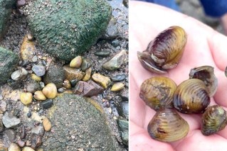
The 16cm size hail that fell near Yalbaroo, north of Mackay, earlier this month set a new record, eclipsing the 14cm hail recorded in south-east Queensland last year and at Kempsey in NSW, in 1991.
One of Australia’s most accomplished hail researchers, the Bureau of Meteorology’s Dr Joshua Soderholm, says severe hailstorms are most common in spring and early summer.
However, the current severe weather season is set to run until April next year.
Just how hailstones can vary in size from a ten cent piece to that of a mango is a complicated process, Dr Soderholm said.
“Hail starts as water vapour near the ground. This condenses into tiny water droplets, cooling as it rises inside a thunderstorm updraft, collecting the really cold water that’s below freezing,” he said.
“This freezing water is called supercooled water and the longer the droplets – and eventually ice – fly through the supercooled water within the thunderstorm updraft, the bigger it grows.
“So whenever you see giant or large amounts of hail on the ground, a lot has to happen for it to get there. It is also why there is not hail in every storm.”
The bureau is forecasting more severe thunderstorms for Queensland throughout this week.